Extreme Precipitation and Climate Change

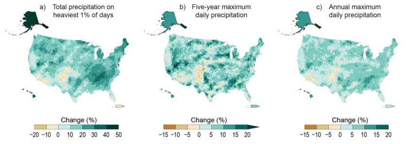
Extreme precipitation events have increased in frequency and intensity in the U.S. and across many regions of the world since the 1950s. These events are defined as instances in which the amount of rain or snow experienced in a location substantially exceeds what is normal. In the contiguous United States, annual precipitation has increased at a rate of .2 inches per decade since 1901, with extreme precipitation events outpacing this trend. The Midwest and Northeast have experienced the strongest increases in heavy precipitation events.

Scientists expect these trends to continue as the planet warms. For each degree Celsius of warming, the air’s capacity for water vapor goes up by about 7 percent. An atmosphere with more moisture can produce more intense precipitation events, which is exactly what has been observed.

Increases in heavy precipitation may not always lead to an increase in total precipitation over a season or over the year. Some climate models project a decrease in moderate rainfall and an increase in the length of dry periods, which offsets the increased precipitation occurring during heavy events. However, the combination of more intense precipitation and an increased frequency of extreme events can lead to changes in overall precipitation levels.

Threats posed by heavy precipitation

The most immediate impact of heavy precipitation is the potential of flooding. This risk can be heightened in urban areas where non-permeable pavement forces water to quickly run off into sewer systems.

Excessive precipitation can also degrade water quality, harming human health, aquatic ecosystems, and fishery operations. Stormwater runoff, which often includes pollutants like heavy metals, pesticides, nitrogen, and phosphorus, can end up in lakes, streams, and bays. This is an issue especially in the many cities in the United States that use a combined sewer system, where both stormwater and wastewater are mixed, treated, and released. Heavy rainfall can overwhelm such systems, sending excess stormwater, wastewater, and untreated sewage directly into bodies of water.

In addition to flooding, heavy precipitation also increases the risk of landslides. This occurs when above-normal precipitation raises the water table and saturates the ground, causing slopes to lose their stability. Washington state, which has a particularly high risk of landslides due to its terrain, anticipates they will become more frequent as a result of climate change-induced increases in heavy downpours.

Recent disasters caused by extreme precipitation include:

  • Extreme rainfall in the summer of 2022 led to flooding that overwhelmed water treatment plants in Jackson, Mississippi, killing three people and leaving more than 150,000 without drinking water. In late July, extreme precipitation caused 8-12 inches of rain fall around St. Louis and 5-10 inches across eastern Kentucky and caused the North Fork of the Kentucky River to reach a new peak height.
  • In August 2021, Tennessee saw extreme precipitation of up to 22 inches in 24 hours, breaking records for the region. This led to widespread flooding and the deaths of at least 21 people.
  • In August 2017, Hurricane Harvey dumped 48 inches of rain on Houston, breaking the U.S. record for most rainfall from a single event and demonstrating that the biggest threat from tropical cyclones is not always coastal flooding and wind damage. Damages from this event are estimated at over $148.8 billion (in 2022 dollars) and more than 89 fatalities were recorded.

How to Build Resilience

In order to reduce the likelihood of extreme precipitation events from occurring, it is critical to address greenhouse gas emissions that are driving it by reducing fossil fuel use and taking other emissions reductions actions. Simultaneously, communities can build resilience against the damaging effects of extreme precipitation by:

  • updating zoning regulations and building codes so that existing and new buildings and infrastructure are built in areas that are less prone to flooding or on higher ground and can withstand future changes in flooding.
  • investing in flood control infrastructure, including grey infrastructure like seawalls and levees if needed, as well as green infrastructure solutions like installing green roofs, enhancing the urban tree canopy, and conserving lands like wetlands. Green infrastructure can be less expensive to maintain and bolster stormwater management capacity while offering significant co-benefits such as enhanced water and air quality and recreational opportunities.
  • limiting the use of non-permeable surfaces like pavement and concrete in urban areas or replacing pavement with green infrastructure that can absorb flood waters and reduce runoff during storms. (See the Hoboken, N.J., Solutions Story.)
  • incentivizing residents to take flood risk reduction actions like floodproofing and home elevation.
  • separating storm water systems from wastewater systems, using holding ponds, or increasing water treatment capacity to avoid sending untreated sewage into local waterways.
  • encouraging residents to purchase flood insurance to cover property losses and business disruptions. When communities implement certain flood risk reduction strategies, they can receive discounted flood insurance rates through the National Flood Insurance Program’s Community Rating System.
  • creating strong flood warning systems for residents.

The Climate Mapping for Resilience and Adaptation portal helps communities understand and plan for their climate risks today and in the future, including a real-time map of wildfire, drought, flooding, and extreme heat across the United States.